Monday, May 18, 2015

California to Oregon; Banana Slugs to Mosquitos

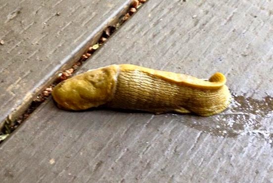
 Banana slug at the Emerald Forest of Trinidad

I spent five blissful days at one of my all-time favorite campgrounds, the Emerald Forest of Trinidad.  I'd planned to stay three nights, but I was enjoying myself so much that I extended a couple more.

Each day, I walked into town and had coffee at the Beachcomber, a little natural foods restaurant in town.  Sometimes I visited the local artists' co-op gallery or a gift shop or the grocery store or the beach or the Humboldt University Marine Research Lab.  It was a nice place to take a break from being on the road.

 An eight-pack of fabulous chocolate bars!


 Trinidad Memorial Lighthouse 
(The real lighthouse is still in use, but it was too much of a hike for me.)


 Mermaid and dolphin sculpture in Trinidad

It was hard to leave Trinidad, California.  I just love that place.  All of the best of the northern Cali coast (beach, Redwoods, cool weather, lots of artists, no biting insects, etc.) in one small place.  I could've had a job there and stayed for the summer, but I passed.  However, Steve and I have applied to workcamp at the Emerald Forest of Trinidad next summer.  We shall see.

With mixed feelings, I headed north on Highway 101 again on Friday.  Fifteen miles north of Trinidad, I was in the Redwood National and State Parks.  This involved more beautiful drives through Redwood trees, similar to what I'd seen further south on the Avenue of the 100 Giants, and also some awesome stretches of road where the highway paralleled the shore.  

I'd expected to camp at a California State Park on Friday night, but I happened across a very nice Del Norte County Park instead.  I've been really noticing how impossible it is to fully research my destinations on the Web.  There are many fine places to camp that don't seem to show up in my Internet research--and I used to be a librarian, so I'm pretty darned good at research.  Florence Keller County Park, north of Crescent City, was $15 per night with no hookups, and it had lovely, large, wooded campsites.     

My campsite at the county park

The view out the back picture window

Before leaving Trinidad, I'd gotten my propane tank refilled, and afterwards I was unable to relight my refrigerator.  So I spent a lot of my time at Florence Keller on my belly on the floor of the rig, where I can reach the fridge controls, but to no avail.  So I got some ice and put it in the vegetable tray, and used the fridge as a cooler for several days.

On Saturday, I headed to Oregon.  I had some wonderful moments that day, visiting a few beaches and scenic outlooks on my way out of California.


 My lunch table at Klamath River Overlook, Klamath, CA

 
 The view at Klamath River Overlook
 
One last California beach walk, at Smith River, CA

And then it was on to Oregon, where the beaches are a little bit more wild and rocky.  All along the Oregon Coast, there are State Parks with campgrounds every 30 or 40 miles, sometimes closer.  I looked at most of them on my way north and finally decided on Cape Blanco State Park, in Sixes, Oregon, which is about 70 miles north of California.  It was a great choice.  

Cape Blanco has a wonderful beach and big wooded campsites, and it was very interesting because the Pacific Coast Trail runs right through the park, so I got to see lots of hikers and even horseback riders passing by my site.


 The approach to the beach at Cape Blanco

 Cape Blanco Beach
 
I liked the park so much that I stayed a couple of days.  It was a nice time.  I took a picnic lunch down to the beach, I had a little campfire one night, and I FIXED THE FRIDGE!  A friend suggested that maybe all that was needed was to remove some corrosion from the igniter.  So I used an emery board on all of the surfaces, and the fridge lit on the first attempt!  I felt very empowered.  And I needed it, too.  I was getting a little travel-weary, and the ever-lengthening list of things that need to be fixed was not helping. 


 An evening in my campsite at Cape Blanco
 
 Riders on the Pacific Coast Trail, just below my campsite

This morning I left Cape Blanco, but not before I took a little drive out to see the lighthouse, where I got another great view of the sea.  Between Cape Blanco and Highway 101 (about 5 miles of beautiful rolling hills), I saw sheep and goats.  I'd intended to drive to Bandon, Oregon, for breakfast, but I found a great greasy spoon in the tiny but world-renowned town of Langlois (famous for its blue-veined cheese).  I had pancakes made with local blueberries.     

 Cape Blanco Lighthouse
 
 A misty morning near the lighthouse

  Baaaaaa


 Where I had breakfast

And that's my story for now.  I decided to stop rather early today, mostly because I came across a much cheaper campground than the State Parks.  I'm at the Horsfall National Recreation Area near Coos Bay/North Bend.  I usually avoid these places because they're full of off-road vehicles, but this one happened to have two campgrounds, one for people with toys and the other for people without.  So I'm at the quieter campground and am about to go explore the area on foot.  It seems like a nice quiet place.  There are about a gazillion mosquitoes, but I'm pretty thoroughly sprayed.  I am close to miles of sand dunes and I can hear some seals barking from my campsite.  Pictures of this next time!    

Sunday, May 10, 2015

California Highway 20 to the Coast, Then North to Trinidad


Reproduction vintage postcard purchased recently, now part of my decor

When I last wrote, I had just seen visited some California Gold Rush history sites and was on my way west to the Pacific Coast.  

On Wednesday, from Coloma, I drove up to Yuba City where I could get onto California Highway 20, heading west. 

 Coastal forest greenery, such a nice change of pace after living in the desert

I'd never been on 20 before.  I'd taken Highway 299 through the Shasta-Trinity National Forest many years ago.  It's a beautiful road, but a lot of this trip is about seeing things I haven't seen before.  I considered taking Highway 36, but I found an article in an online motorcycle magazine that said Highway 36 is one of the craziest highways to drive in the country!  No, thanks!  I find enough of those without trying.
  
So Highway 20 was the choice, and I'd planned to stop at a State Recreational Area on the Sacramento River in Colusa, where I could get a parking lot style campsite with no hookups for $13.  However, I lucked out and saw billboards for a casino in the same area, so instead I camped in the Colusa Casino parking lot at no cost.  In fact, I made a little money on the deal, because they gave me a players club card with $20 credit on it, and I got $23 cash from the free play. 

 My navigator, falling down on the job again...

When I left on Thursday morning, there were strong winds in the Sacramento River valley as I continued to drive west on Highway 20.  I got to the huge, beautiful Clear Lake which is surrounded on all sides by resorts, motels, campgrounds, marinas, etc.  It was still windy near the lake, so I stopped for the night--again, an unexpected casino stop at Robinson Rancheria, where I won a little on the slots, but dropped a bundle playing bingo with some really nice senior ladies who took the casino bus in from Ukiah.  They coached me through the games and showed me how to use those newfangled bingo machines.   

I woke up on Friday morning with a slight headache, sore throat, and cough, and wondered what the heck was going on.  Then I realized I'd been breathing far too much secondhand smoke in the casinos, especially when I stayed to play bingo for several hours.  So I was very motivated to get to the beach where I could breathe some fresh air.

First glimpse of the Pacific Ocean for a few years...aaaaaaaahhhhhhh, that's better

I headed west all the way to Highway 1 which runs right along the Coast itself.  I first stopped to see the Pacific at a viewpoint in Fort Bragg, but, as I headed north, I stopped many times to admire the views and check out possible campsites. 

I was not at all impressed with the California State Beaches in this area.  Sadly, they are very poorly cared for these days.  I could have stayed at one of these campgrounds on cliffs overlooking the beach, but it was $25 a night and the facilities were awful, especially the bathrooms.   


My idyllic free boondocking site, with a million dollar view--I sat at the dinette in the back of the rig and looked out the picture window for many hours

So instead, I looked for and found a site that was recommended on freecampsites.net.  Most of the scenic viewpoints along Highway 1 are marked and have signs in their parking lots that say no camping allowed.  But there are a few pullouts that have no signage, and I stayed in one of these.  It was a beautiful place to spend the night.  There were rocks along the shoreline that the waves crashed over.  


The view looking south along the coastline from my boondocking site

Yesterday morning, I drove up Highway 1 to where it intersects with Highway 101 (more winding mountain roads!), stopping in tiny Leggett for a very good breakfast at Rising Sun Cafe & Grill, owned by a nice Costa Rican guy who can really cook.  Driving north through Garberville, I stopped to buy fresh cherries right across the street from the One-Log House that I so enjoyed visiting on my way south on 101 a little over four years ago, when I left the Pacific Northwest.  

Driving along the Avenue of the Giants.  Note that these trees are each as wide as a lane of traffic.

Near Humboldt Redwoods State Park, I noticed signs along the road for a scenic route called Avenue of the Giants, which sometimes parallels and crosses Highway 101 while it winds through groves of redwoods.  It was an awesome drive.  I was about halfway through it when I got to the State Park headquarters at about 2 p.m.  I stopped in to talk about camping both in the Park and at some nearby BLM sites, and found out that the BLM campgrounds required driving more switchbacks through the mountains.  

So I plunked down $35 for a campsite at the State Park, where I had a very nice time.  The redwood forest is so deep and dark that I had to use my interior lights in the RV even during the middle of the day.  So I was inclined to stay outside and seek what sun I could find.  

My campsite at Humboldt Redwoods State Park, Burlington Campground

I went to a ranger talk and campfire that night to learn more about the redwoods, which are pretty incredible and not only because of their size.  Did you know they get moisture by breathing fog?  That their cones are some of the smallest evergreen cones?  That their burls, which are a sort of abnormal growth in response to stress, are packed with little baby trees and are their primary means of reproduction?  Cool, but mostly I stayed for the opportunity to toast marshmallows after the ranger stopped talking.  

I like the State and National Parks.  They bring out all my Girl Scoutish qualities, which I tend to have a lot of.  I like knowing that my pearl pocketknife and my 25-year AA coin are in one pocket, and my RV keys are in the other.  I like knowing exactly where to find my flashlights, tools, popcorn, marshmallows, roasting forks, and other camping necessities.  I can usually start a fire with just one match, and I generally wear a uniform of either cargo shorts or jeans with a funny cat T-shirt and plenty of cat hair.  I might have made a good park ranger if I hadn't been scared of the science.

 My campsite at The Emerald Forest--look at the big stump next-door!

At $35 a night, I had to leave the State Park and keep heading north, which actually made me very happy because today I made it to Trinidad, one of my favorite places in northern California.  I am staying at The Emerald Forest of Trinidad, a resort that has tent sites, RV sites, and cabins.  There are showers and laundry and a little store.  The campground itself is in the redwoods, but just about a quarter-mile down the road is the little town of Trinidad, which is on the beach and gets lots of sunshine.  I am going to stay and relax here for several days.  I loved this area when I visited it before, and I would like to see more of it this time.  WIFI is good here, so not only am I getting this blog posted, I'll also be able to pay a few bills and maybe catch up on a few TV episodes.  I'm taking a little vacation from my vacation here.       

Tuesday, May 5, 2015

Bucket List Items Checked Off--Yosemite and the California Gold Rush


Solveig, my Toyota Dolphin, parked at Yosemite


After staying at some relaxing Corps of Engineers campgrounds in the foothills of the Sierra Nevada last week, I decided it was time to move on to a couple of the places in California that had intrigued me ever since I was a kid.  Most of my past travels in California have been along the Coast and across the southern part of the state heading towards Arizona.  So I'd never been to Yosemite National Park before, nor had I seen any of the California Gold Country.

I knew nothing about the campground reservation system at Yosemite, but apparently they release a new block of reservations each month, for five months in the future.  Californians who regularly vacation at Yosemite know the drill.  Families pick out the sites they'd love to have, and then on the appointed day, several family members will have Yosemite's campground reservation number on speed-dial and also on their computer screens, and they'll see who can get in first and make the booking.  

Wow!  I was really lucky, because I looked up reservations on-line and got one night at the North Pines Campground right when it fit into my schedule.  

A couple of fan kiwis, the most delicious kiwis I'd ever tasted

I headed up to Oakhurst, one of the towns closest to Yosemite, and spent one night in an RV park so I'd be ready to drive to Yosemite early the next morning.  On my way to Oakhurst, I stopped at a wonderful fruit stand where I bought some of the freshest, most delicious California fruits and vegetables I've ever tasted. 

The next morning, I got underway by about 8 a.m., so I was in the park and enjoying the sights before it got very busy.  I made all of the usual stops that people make as they drive into Yosemite from the south.  Highway 41 gains elevation and the forest gets thicker.  I don't know what the elevation is at the South Entrance, but it's high enough that, just inside the gate, you find the Mariposa Grove of Giant Sequoias.  It's about a mile hike to see the first of these great trees, and further if you want to see them all.  I liked even the parking lot, though.

From the entrance, it's about an hour's drive to Yosemite Valley, which is where most of the visitor-related activities happen.  

Wawona Tunnel View of Yosemite Valley

Along the way, you go through the Wawona Tunnel, and immediately afterward you come out the north end, it's traditional to stop and be amazed by the scenery. 

Yosemite is about 12,000 acres, most of it wilderness, but it's mostly pretty serious hikers and climbers who get outside Yosemite Valley to explore the rest of the park.   People who drive in and stay at a lodge or RV campground usually just see the Valley, which includes Yosemite Village and Curry Village as well as the beautiful Ahwahnee Lodge.

There is also another valley, Hetch Hetchy, and some other outlying areas that have campgrounds open later in the year.  Arriving in late April, some roads and activities aren't open yet. 

 View of the Merced River from a bridge near my campground

In Yosemite Valley, there are a variety of lodging options, from fancy lodges through walk-in campgrounds.  I'd forgotten, but you can camp at Yosemite even if you don't have camping gear!  There are a couple of tent villages where you can rent a platform tent or a sort of hut.  

The campground I was in, North Pines, was one of the smaller campgrounds for people who bring their own tents or RVs.  It was very pleasant, and I had an outstanding campsite that was shaded, close to the bathroom, and bordered on the Merced River, with no neighbors very closeby.  (Loop 4 #500, if you're ever making reservations yourself.)

What a surprise, to run into Charlene Armstrong, whom I'd met last summer in Tucson

Once I got settled in my site, I ate some lunch and then headed out to spend the afternoon exploring.  I took the free shuttle buses and visited Yosemite Village, where there is a great Visitor Center with films, exhibits, and plenty of self-guided trails and other sites nearby.  I was amazed at the Visitor Center to find Charlene Armstrong, a woman who had been staying at the same RV park in Tucson where I was last summer while having my total knee replacement.  It was great to get reacquainted with Charlene, who is now on the road full-time with her husband.  I also visited Curry Village, some stables, a history area where old buildings and wagons are gathered, and, of course, a few gift shops, galleries and restaurants.  

I had to get on my way the next morning, because I had only the one night reserved at the campground.  There is a procedure for seeing if you can get a site due to a late cancellation, but it involves putting your name on a list and then returning to the reservation office at 3 p.m. to wait in line and see what happens.  Even though I would have loved to stay longer, I didn't think I would deal well with trying to get out of the park and find another place to camp if I didn't get a Yosemite Valley campsite in the late afternoon.

El Capitan, one of the famous rock faces in Yosemite

I'm glad I moved on, because it really took a while to drive to my next destination.  I took Highway 120 out through the north end of the Park, stopping for one last picnic in Yosemite before leaving.  I drove up into the California Gold Country, along Highway 108, and stayed at Black Oak Resort Casino in Tuolumne.  There is no RV park at the casino, but they let RVs park on an upper lot.  It was very secure, with the casino's security office in the same parking lot, and it was an easy walk down to the casino itself where I ate a very good Friday night seafood buffet and won a few bucks on the credit they gave me for joining the Players Club.  I spent a second night there, just because it was relaxing and free (although the $20 I dropped in the slots the second night was kind of like paying for my RV space.)  

After casino camping, I headed out on Sunday morning, thinking I would drive only a short ways further north on Highway 49 into more of the Gold Rush area.  I figured I'd stop and see the little historic towns.  But it was a great day for driving.  Not too hot, lots of beautiful sights to see.  I got into some gorgeous foothills ranching and farming areas, with orchards and happy California cows everywhere.  It was mountainous driving with  occasional 12 percent grades and hairpin turns, but mostly it was just rolling hills.  I covered a lot more miles than I'd expected.  Along the way, I decided maybe I don't need to stop at every little Gold Rush town.  Maybe I would just head for where the Gold Rush actually started and then head for the Coast.

 Level II rapids on the American River, right in front of where I'm camped in Lotus

So I ended up at Ponderosa Resort in Lotus, California, which is along the American River, just down the road from Coloma, the site of Sutter's Mill, where the first discovery of gold was made.  I arrived at Ponderosa on Sunday, and yesterday I spent a good part of the day walking over to the Marshall Gold Discovery State Historic Park.  Marshall was a business partner with Sutter, the founder of Sacramento.  He built a lumber mill and then noticed some shiny flecks of gold, which eventually led to about 90,000 people coming to California to see if they could find gold, too.  

The resort I'm staying at is a really good deal for me--$10 per night using my Resort Parks International membership.  I'm pretty tired from my long walk yesterday, so I'm thinking I'll stay one more day here where I have good wifi, showers, etc.  Then tomorrow I will start heading towards the Coast.

   My shaded campsite near the American River at Ponderosa Resort